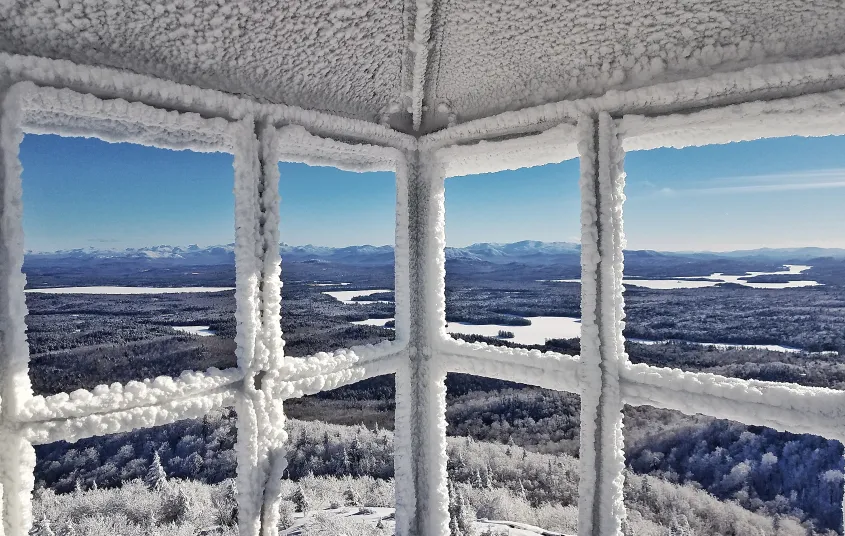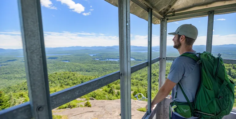


A climb to the summit yields magnificentviews in nearly all directions. McKenzie Mountain and the High Peaks can be seen tothe south. Directly below is an outspread of lakes and ponds within theSt. Regis Canoe Area. A successful hike of Ampersand, one of the Saranac Lake 6ers, involves research, physical fitness, the right gear, and knowledge of Leave No Trace principles.
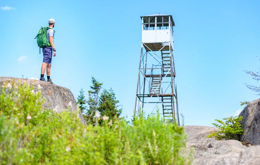
The summit also has a restored fire tower. Built in 1918, the fire tower on St. Regis Mountain has been a fixture on the landscape for over 100 years. It was an active fire tower observation station until 1990. The tower was then closed and began to deteriorate. In 2015, the Friends of St. Regis Mountain Fire Tower officially formed and restoration work commenced. Since then, much work has been done to restore the tower to its former glory and it is open to climb today.
Key takeaways
- Distance: 6.8 miles round trip
- Elevation gain: 1,650 feet
- Elevation: 2,874 feet
- Hike includes trail junctions and a bridge
Hiking St. Regis Mountain
From the parking lot, you will have to walk up the dirt road for a short distance to the foot trail on the right. From the DEC register, the footpath starts off very moderately over rolling hills. The gentle trail is inviting as you gain elevation steadily. Just over 2 miles from the register, you will cross over a bridge. This is where the climbing begins.
From here, the trail becomes steeper as you near the summit, but well-maintained stone steps and other features make the climbing a little friendlier. You will encounter the steepest sections in the last 0.3 miles before the summit. Through the trees, you may even get a sneak peak at the expansive views to come. Just below the summit, you'll emerge onto open rock and the restored fire tower will appear.
Views to the south are clear after being accidentally scorched by a fire started by Adirondack surveyor Verplanck Colvin in 1876.
St. Regis in the winter
This trail is an excellent snowshoe. Since the footpath gets steeper toward the summit, microspikes are highly recommended as it can be icy. While lake ice conditions can be variable and unpredictable, when the conditions are right, skiing from the Upper St. Regis Lake boat launch to Spring Bay to hike up the lake trail makes for an enjoyable outing. Ski across the frozen lake and then switch to snowshoes at the dock. Snowshoes are necessary to avoid post-holing through the snowpack, and microspikes are required to ascend the mountain's steeper sections. Extra layers of non-cotton clothing, a windbreaker, emergency blanket, first-aid kit, headlamp with extra batteries, and plenty of food and water are essential items for any winter excursion. The extra layers and windbreaker are especially important on the partially-exposed summit, which will be much colder than the lower sections of the mountain.
Explore more trails
Does St. Regis sound amazing, but a little more than you want to tackle right now? No need to stress, we can help you find a uniquely Saranac Lake trail that’s right for you!
How to get there
From the intersection of Route 30 and Route 3 in Tupper Lake, follow Route 3/30 toward Saranac Lake. Once Route 3 and Route 30 split, take a left and follow Route 30 toward Fish Creek. Stay on Route 30 and pass through Lake Clear and into Paul Smiths. Take the first left after Paul Smiths College onto Keese Mill Road. Follow Keese Mill Road for just under 3-miles to the trailhead parking on the left.
An alternative trail can turn this terrestrial hike into a bit of a "surf-and-turf." There is a new dock (2019) located in Spring Bay of Upper St. Regis Lake and boaters or paddlers are welcomed to dock here and climb ~1 mile trail to its intersection with the main trail from Keese Mill Road. Starting from the lake, the trail climbs an esker steeply at first but eventually flattens out as it nears the intersection. Boaters can launch at the DEC launch on Upper St. Regis Lake and paddlers can put-in Paul Smith's College or at the Upper St. Regis Lake launch.


Packages and Promotions
Valid Nov. 30
Valid Nov. 18 - Nov. 30
Raquette River Brewing - Cyber Monday
Raquette River Brewing
Cyber Monday Brews & Adirondack Views (From Your Couch!)
Get cozy this Cyber Monday and support local businesses from the comfort of y
Valid Jul. 3 - Aug. 30
Valid Jul. 1 - Aug. 30
Classic Films, Summer Vibes – Only $5
Adirondack State Theater
$5 classics. Cool theater. Daily at 4 PM. All summer long, the Adirondack State Theater brings timeless films to the big screen for just five bucks.
Valid Dec. 4 - Dec. 6
Valid Nov. 19 - Dec. 6
Holiday Stroll Cocktail Features
The Woodshed on Park
Get into the holiday spirit during the Holiday Stroll with seasonal cocktail features crafted just for the weekend.
Valid
Valid Sep. 26 - Oct. 28
weekly on Wednesday until October 29, 2025
Witchy Wednesdays Cocktail Features
The Woodshed on Park
Witchy Wednesdays—a month-long celebration of spooky season with enchanting cocktails crafted to thrill your taste buds.
Valid Jun. 30 - Jun. 30
Valid Jul. 13 - Jun. 30
Book Now, Adventure Later with Trailhead
Book two or more consecutive nights 45+ days in advance and receive up to 20% off, with the flexibility to adjus
Valid Nov. 28
Valid Nov. 19 - Nov. 28
Small Business Saturday at Cabin Fever Floral
Cabin Fever Floral & Gifts
Cabin Fever is dicounting everything in the store 20%, sample our ADK Chocolates and enter to win a Christmas arrangement.
Valid Mar. 31 - Oct. 30
Valid Apr. 14 - Oct. 30
Fish & Stay
Voco Saranac Lake
Enjoy a 2-hour fishing session on Lake Flower for two, guided by expert anglers.
Valid Nov. 13
Valid
10 Year Anniversary at Spruce & Hemlock
Spruce & Hemlock
Our 10 year Anniversary is on November 15th!
Valid Nov. 30 - Jan. 27
Valid Nov. 19 - Jan. 27
Tupper Motel December / January Room Special
Escape to Tupper Lake This Winter!
Cozy Rooms, Unbeatable Rates at the Tupper Motel
Looking for a winter getaway that combines co
Valid Aug. 7 - Aug. 14
Valid Aug. 7 - Aug. 14
Spruce & Hemlock: End of Season Clothing Sale
Spruce & Hemlock
Join us for our End of Summer Sale with prices starting at just $10.00!
Valid
Valid Jun. 15 - Oct. 15
weekly on Wednesday until October 16, 2025
Wing Wednesdays: Full Flavor, Half Price!
The Clubhouse at TLGC
Dig in and save big! Join us every Wednesday at The Clubhouse at Tupper Lake Golf Club for Wing Night Wednesdays, featuring 50% off chicken wings from 4:00 to 8:30 PM.
Valid Jun. 30 - Sep. 29
Valid Jun. 30 - Sep. 29
weekly on Monday, Tuesday, Wednesday, Thursday, Friday, Saturday and Sunday until September 30, 2025
Timberjaxx Pass Loyalty Card
Timberjaxx Pass
Get the Timberjaxx Loyalty Card and earn a free game after five rounds. Fun, treats, and no card to carry.
Valid
Valid Jun. 15 - Oct. 16
weekly on Tuesday until October 21, 2025
Taco Tuesday at RRB
The Marketplace - Food Truck
Free RRB Margarita with Your Marketplace Food Truck Tacos
Join The Marketplace Food Truck and Raquette River Brewing for the ultimate Taco
Valid Nov. 25
Valid Nov. 24 - Nov. 26
Half Price Bowling & Shoes
Lakeview Lanes
Thanksgiving Eve Special at Lakeview Lanes
Kick off the holiday weekend wit
Valid Sep. 26
Valid Sep. 24 - Sep. 26
Free Pool All Day at P-2's Irish Pub
P-2's Irish Pub
Free Pool at P-2's Irish Pub
Valid Mar. 31 - Oct. 30
Valid Apr. 14 - Oct. 30
Paddle & Stay
Voco Saranac Lake
Escape to the serene beauty of the Adirondacks and immerse yourself in nature as you paddle the tranquil waters of Lake Flower in a kayak, canoe, or SUP
Valid
Valid Nov. 25 - May. 28
weekly on Tuesday until November 25, 2026
PorkBusters BBQ Taco Tuesdays!
Pork Busters - Food Truck
Who doesn’t love Taco Tuesday?
Valid
Valid Jul. 22 - Aug. 30
weekly on Monday, Tuesday, Wednesday, Thursday and Friday until August 30, 2025
Caribbean Kitchen Takeout
Faust Motel
Caribbean Kitchen Pop-Up Takeout Returns
We’re excited to announce the retu
Valid Nov. 27
Valid Nov. 18 - Nov. 27
Raquette River Brewing - Black Friday!
Raquette River Brewing
Score Big on Black Friday at Raquette River Brewing!
Looking for the perfect Adirondack souvenir or a gift for the craft beer lover in you
Valid
Valid Mar. 31 - Mar. 31
The Wild Center Family Getaway
Voco Saranac Lake
Enjoy 2 adult and 1 child admission tickets to The Wild Center, where nature meets discovery.
Valid Nov. 27 - Nov. 28
Valid
Small Business Saturday
Tupper Arts
Black Friday and Small Business Saturday are headed to Tupper Arts on November 28 and November 29, 2025.
Valid Jul. 13 - Jul. 13
Valid Jul. 13 - Jul. 13
3rd Night Free at Trailhead
Book two consecutive nights at our regular Best Available Rate and get your 3rd night on us. Staying longer than three nights? 3rd Night Free! is available for EVERY 3rd night.
Valid Mar. 31 - Oct. 30
Valid Apr. 14 - Oct. 30
Bike & Stay
Voco Saranac Lake
Explore the beauty of Saranac Lake and the newly developed Adirondack Rail Trail.
Valid Mar. 31 - Jan. 29
Valid Jan. 20 - Jan. 20
Pet Getaway
Voco Saranac Lake
Your dog deserves an Adirondack getaway too. Book our pet friendly hotel near Lake Placid welcomes every member of your crew. Book our Pet Package and enjoy a dog friendly room with pet fees included.
Valid Mar. 31 - Oct. 30
Valid Apr. 14 - Oct. 30
Golf & Stay
Voco Saranac Lake
Tee off at one of the Adirondacks' historic golf courses, surrounded by breathtaking mountain views.
Valid
Valid Dec. 19 - Jan. 30
weekly on Friday until January 31, 2026
Buns & Brews Special
P-2's Irish Pub
Every Friday, P-2's Irish Pub on Main Street in Tupper Lake offers our delicious Buns & Brew Special.
Valid Nov. 27 - Nov. 29
Valid Nov. 13 - Nov. 29
Three-Day Holiday Sale at Spruce & Hemlock
Spruce & Hemlock
Holiday Sale at Spruce & Hemlock!
Valid Sep. 5 - Sep. 24
Valid Sep. 7 - Sep. 23
Fall Foliage Special
Northwood Cabins
Three nights for the price of TWO!
Valid Jan. 20 - Jan. 20
Valid Jan. 20 - Jan. 20
Stay and Dine
Voco Saranac Lake
Receive a 50 dollar credit per stay to use in our Lakeside Drift. Enjoy an exceptional dining experience with unparalleled views great food and craft beers in a friendly and relaxed environment.
Valid
Valid Dec. 18 - Feb. 27
weekly on Wednesday until February 28, 2026
Wine Down Wednesday
P-2's Irish Pub
Unwind midweek with 2-for-1 house wines every Wednesday during happy hour from 4-6 p.m. at P-2’s Irish Pub on Main Street in Tupper Lake.
Valid
Valid Sep. 6 - Feb. 7
weekly on Sunday until February 8, 2026
Sunday GameDay Specials
Foul Line Sports Bar at Lakeview Lanes
Lakeview Lanes is Tupper Lake’s go-to destination for fun—whether you’re here for bowling, arcade games, or catchin
Valid Jun. 30 - Jun. 30
Valid Jun. 30 - Jun. 30
Tri-State Resident discount at Trailhead
Residents of New York, New Jersey, and Connecticut are invited to enjoy savings of up to 15% on your next Adiron
Valid Nov. 28
Valid Nov. 25 - Nov. 28
Small Business Saturday at Ray's Discount Liquor
10% off on these specific liquor and wine.
Berlinger Founders Cab 1.5L and 75
All Boda Box 3 Liter
Machio Prosecco
Valid Jun. 30 - Jun. 30
Valid Jun. 30 - Jun. 30
Stay More, Save More with Trailhead
Valid
Valid Jun. 13 - Oct. 15
weekly on Monday until October 14, 2025
Mexican Mondays
The Clubhouse at TLGC
Head to The Clubhouse for bold flavors, rotating Mexican dishes, and $6 margaritas every Monday.
Valid
Valid Jun. 15 - Oct. 15
weekly on Friday until October 17, 2025
$20 Fish Fry Friday
The Clubhouse at TLGC
Get Hooked on Fish Fry Friday at The Clubhouse
Join us every Friday at The Clubhouse at TLGC for a delicious Fish Fry Friday tradition.
Valid Nov. 27 - Nov. 28
Valid Nov. 24 - Nov. 28
Small Business Saturday
The Adirondack Store & Gallery
Adirondack Store and Gallery will be starting the Christmas shopping season off on Black Friday and continue through Small Business Saturday.
Valid Nov. 28
Valid Nov. 18 - Nov. 28
Raquette River Brewing - Small Business Saturday
Raquette River Brewing
Celebrate Small Business Saturday with Raquette River Brewing!
Skip the big box stores and connect with the heart of Tupper Lake this Smal
Valid Nov. 27 - Nov. 29
Valid
Holiday Sale at Spruce & Hemlock!
Unwrap Holiday Cheer at Spruce & Hemlock!
Discover the perfect gifts for everyone on your list at Spruce & Hemlock's Holiday Sale!
Valid
Valid Dec. 8 - May. 21
weekly on Thursday until May 28, 2026
Thursday Meal Deal
Raquette River Brewing
Thursday Deal at Raquette River Brewing! Every Thursday, head to Raquette River Brewing for a deal you won't want to miss. Spend $14 at LJ Food Truck and/or Fusion Street and receive a FREE drink token for your next round at the brewery. This special...
Valid Jul. 31 - Aug. 2
Valid Mar. 31 - May. 30
BikeADK Loves Canada - Weekender
Canadian Residents can use the code “BikeADKLovesCanada" will receive 15% off their registration!
Valid
Valid Jun. 15 - Aug. 30
weekly on Friday until August 31, 2025
2 for 1 Happy Hour Cosmos and Friday Fish Fry
P-2's Irish Pub
Start your weekend right with 2-for-1 Cosmopolitans for just $8 every Friday at P-2’s Irish Pub—plus don’t miss our Friday Fish Fry!