


44.131974, -74.921746
High Rock is part of the High Falls Loop, but makes for a nice destination on its own for a day hike or an overnight. This is also a popular spot to stop while paddling the Oswegatchie River, and is located in the Five Ponds Wilderness Area, a 107,230-acre wilderness with trails that can take you to some of the more remote areas in the Adirondack Park.
Key takeaways
- Distance: 8.2 miles round trip
- Elevation gain: 375 feet
- Hike includes trail junctions
Hiking to High Rock
From the trailhead you will be on a very mellow hike along an old railroad grade, following red trail markers and blue CL50 trail markers. You cross over Skate Creek a couple times, and in some instances it can be very wet. Soon, a wide tributary of the Oswegatchie River comes into view on your right.
The flat trail continues and eventually you will come to an area where you can see the Oswegatchie River off in the distance through the trees. High Rock comes soon after with an outstanding overlook above the river. Look for the sign at the junction, which is for the 0.1 mile spur trail to High Rock on your right. There are ample designated primitive campsites at this location.
High Rock in the winter
This trail is accessible in the winter, and with the relatively flat grade for a majority of the hike, can be a decent option for those who have some experience cross-country skiing in the backcountry and want to try a higher-mileage trip. While flat, it is long and brings you deep into the backcountry, where you will likely be alone in the winter. As such, be prepared for all winter conditions. Bring layers, ample food and water, skis or snowshoes, and all other winter essentials.
Discover more trails
Looking to find some more trails to hike? With endless mountains, lakes, and waterfalls to visit in the Adirondacks, there are always more trails to discover!
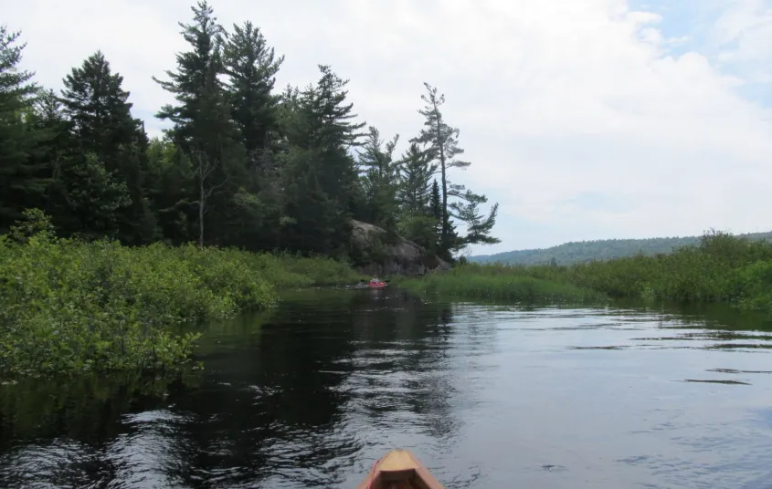
Paddling to High Rock
Paddling the Oswegatchie River is a classic Adirondack trip, and the paddle to High Rock can give you a taste of what a longer trip on this river could be like. It is a 3.3 mile paddle along the winding Oswegatchie River to the base of High Rock.
How to get there
From the intersection of Route 3 and Route 30 in the Village of Tupper Lake follow Route 3 toward Cranberry Lake. Follow Route 3 for 33.4 miles to CR61 (Wanakena Road) on the left. Follow here and stay straight on the main road to South Shore Road. Follow South Shore Road for around 0.25 miles to the trailhead parking on the right. You will have to walk back up the road for a couple hundred feet to the road on the left and walk this to its end, which is about 0.1 miles.
To paddle to High Rock: From the intersection of Route 3 and Route 30 in the Village of Tupper Lake follow Route 3 toward Cranberry Lake. Follow Route 3 for 36.4 miles to Inlet Road on the left, 3 miles past where you turn left to get to the hiking parking lot. Follow Inlet Road for 3 miles to the put-in on the Oswegatchie River.


Websites
- https://dec.ny.gov/places/five-ponds-and-pepperbox-wildernesses
Packages and Promotions
range
Valid Jan. 20 - Jan. 20
Valid Jan. 20 - Jan. 20
Pet Getaway
Voco Saranac Lake
Voco Saranac Lake
Your dog deserves an Adirondack getaway too. Book our pet friendly hotel near Lake Placid welcomes every member of your crew. Book our Pet Package and enjoy a dog friendly room with pet fees included.
package
Other
range
Valid Jan. 20 - Mar. 30
Valid Jan. 20 - Mar. 30
Titus Mountain Ski Package
Voco Saranac Lake
Voco Saranac Lake
Enjoy your stay at the award winning voco Saranac Lake which includes two adult lift tickets at Titus Mountain Family Ski Center. Additional complimentary amenities include ski storage at the hotel and preferred parking at the mountain.
package
Activities and Attractions, Ski
recurring
Valid
Valid Dec. 8 - May. 21
Every week on Thursday.
Thursday Meal Deal
Raquette River Brewing
Raquette River Brewing, Fusion Pizza - Food Truck, LJ's Food Truck
Thursday Deal at Raquette River Brewing! Every Thursday, head to Raquette River Brewing for a deal you won't want to miss. Spend $14 at LJ Food Truck and/or Fusion Street and receive a FREE drink token for your next round at the brewery. This special...
promotion
Dining Deals
1
week
Th
recurring
Valid
Valid Oct. 31 - Apr. 29
Every week on Sunday.
Buy One, Get One Bloody Mary Sundays!
Raquette River Brewing
Raquette River Brewing
Sunday Funday: BOGO Deal at Raquette River Brewing. Join us every Sunday for a delicious deal you won't want to miss! Buy one, get one FREE on our famous Bloody Marys and Bloody Caesars! Made with our secret RRB Bloody Mix, these cocktails are the...
promotion
Dining Deals
1
week
Su
recurring
Valid
Valid Jan. 15 - Mar. 28
Every week on Friday.
Fish Fry Fridays at P-2's Irish Pub
P-2's Irish Pub
P-2's Irish Pub
Every Friday, head to P-2's Irish Pub in Tupper Lake for the best fish fry in town. Enjoy perfectly crispy, golden fish paired with your favorite sides and a cold drink in a warm and welcoming atmosphere. Where: P-2's Irish Pub, 31 Main Street, Tupper...
promotion
Dining Deals
1
week
Fr
range
Valid Jan. 20 - Jan. 20
Valid Jan. 20 - Jan. 20
Stay and Dine
Voco Saranac Lake
Voco Saranac Lake
Receive a 50 dollar credit per stay to use in our Boathouse Saranac Lake Pub. Enjoy an exceptional dining experience with unparalleled views great food and craft beers in a friendly and relaxed environment.
package
Activities and Attractions, Dining Deals
Discover More
Totally Tupper Lake
High Rock
It's been an odd winter so far with the warm weather and unpredictable snowfall. However, depending on where you go, the snowfall could be adequate enough to ski on. This was the case in the Five Ponds Wilderness Area, just prior to the recent warm...

Totally Tupper Lake
High water to High Rock!
Where is the Oswegatchie? When you look at the Adirondack Paddler's Map, the Oswegatchie River seems to be everywhere -- that is because it's 137 miles long! Its mouth is at the St. Lawrence River and it has two main branches, Middle and West, and...
